Sluisbuurt:
Urban island located on the IJ waterway
Sluisbuurt, Zeeburgereiland
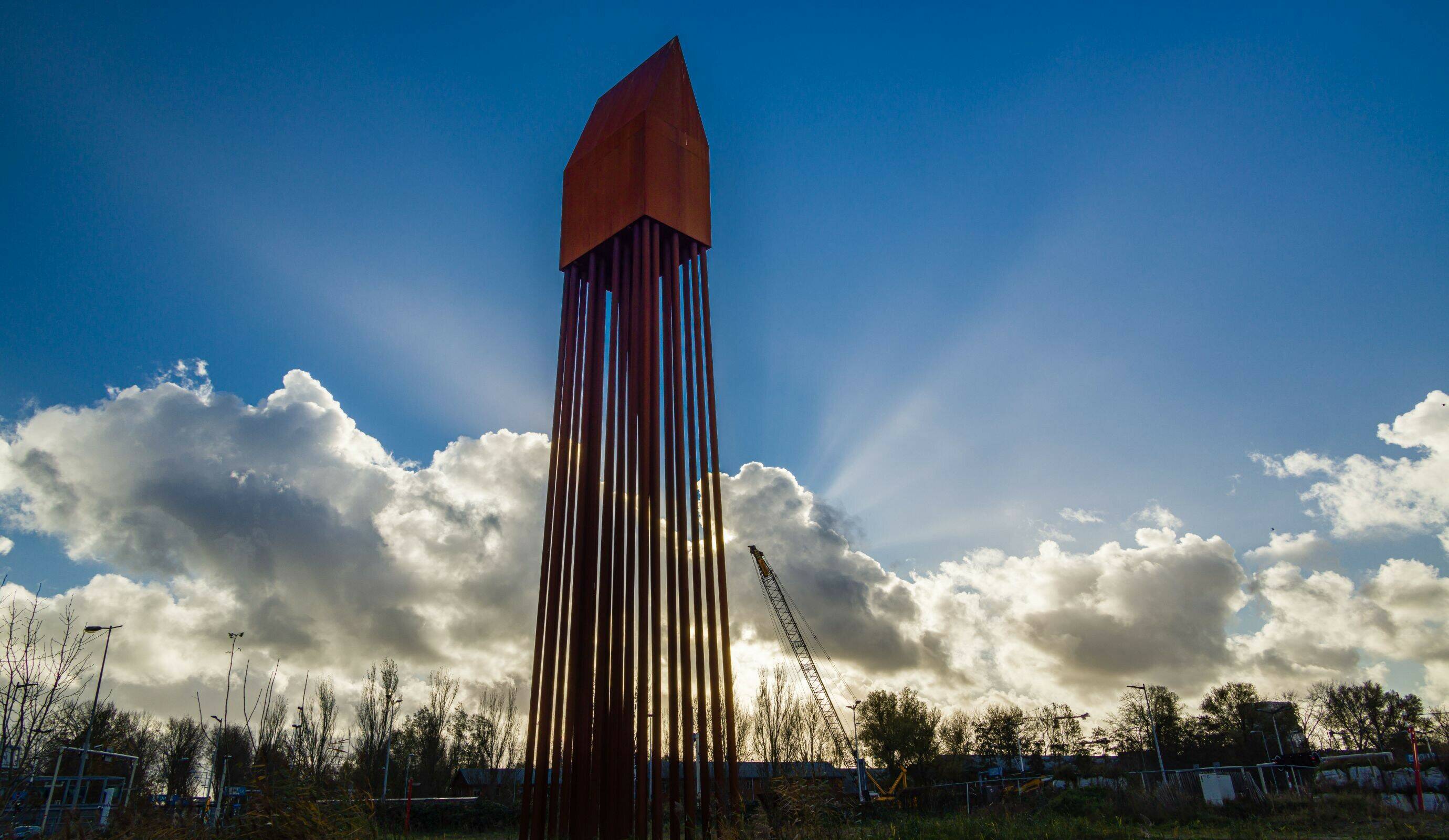
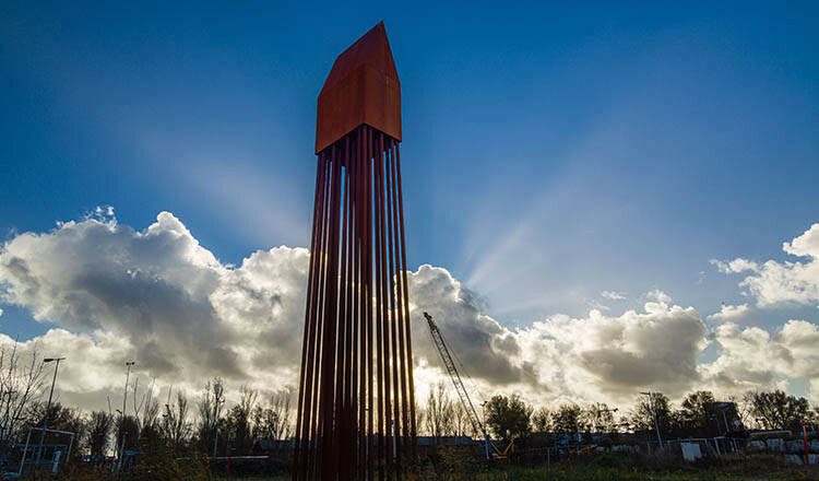
Local landmark: the Palenhuis (designed to celebrate the humble pile). “If you want to go into the air, you first need to get into the ground.”

The skyline of the Sluisbuurt district tells a story: ‘Look, the city doesn’t end there! There’s more! We’re seeing the start here of a whole new section of Amsterdam: the Zeeburgereiland and IJburg island group.’
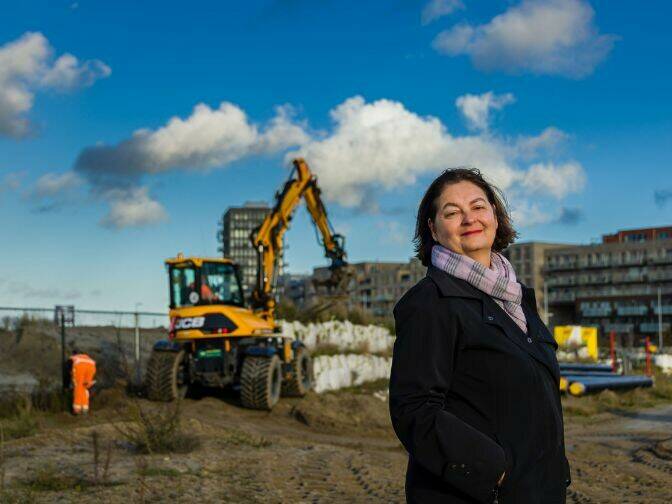
By: Hans Fuchs
Photo credit: Paul Tolenaar
Around a decade from now, the top of the Zeeburgereiland island will be home to a brand-new Amsterdam district: the Sluisbuurt. On the banks of the Binnen-IJ waterway, this residential island will boast green areas and high-quality public space. Right behind, the district starts its giddy ascent, with 17 residential towers creating a powerful urban skyline. So why this focus on the water? What’s with all these towers? And how do the designers integrate sustainability into the public space? Chief designer Mirjana Milanovic outlines the plan for the Sluisbuurt district.

DUWO student housing, Mei architecten
InHolland University of Applied Sciences, cepezed
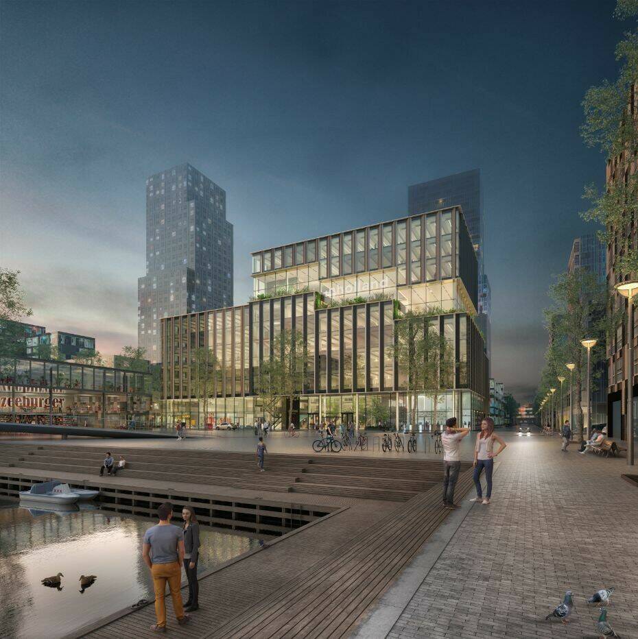
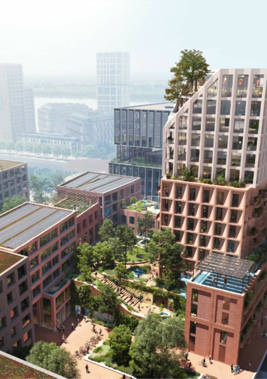
Sluisbuurt 2030, Waterplein with InHolland building, cepezed and Justus tower, Architecten Cie
Urban planner Mirjana Milanovic: “Just look at it: the Sluisbuurt district and the water belong together.” “If you visit the bare, windy sand plain that currently makes up what will become Sluisbuurt district, you can instantly see what makes this spot so special: the water and the unobstructed and panoramic views.”
Milanovic incorporated both these assets into her Urban Development Plan. “The entire waterfront in Sluisbuurt will be used as public space, with the Sluispark section at the farthest point, near the Oranjesluizen sea locks. This will become a metropolitan public space – and not just for the neighbourhood residents. We are using the construction of the Sluisbuurt in order to put the Oranjesluizen locks back on the ‘mental map’, so to speak, of all Amsterdam residents, as part of the city.”

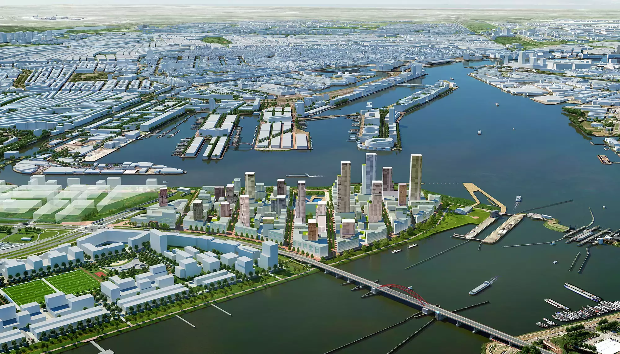
Sluisbuurt water connections, zoning map 2017

Impression of the canal with park and natural banks
Extending the city
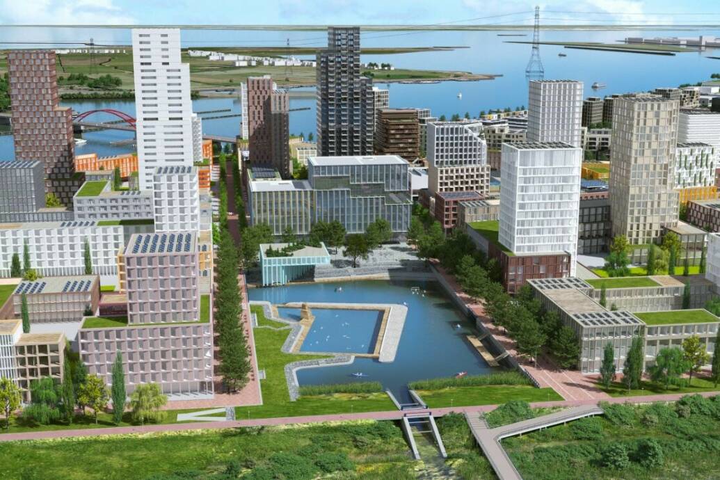
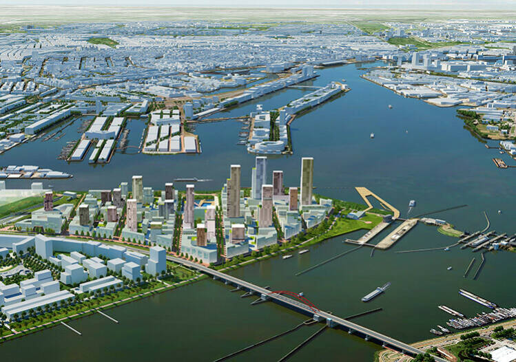
And then there are the panoramic views all around. The Sluisbuurt district is using this to its full potential, with medium-height buildings along the shoreline and 17 towers of between 40 and 125 metres in height. “Residents will be able to enjoy panoramic views: over the city, the village of Durgerdam, the Buiten-IJ waterway, Pampus, and further on, towards Almere.”
The towers will give Amsterdam a powerful new skyline on the Binnen-IJ waterway. This integrates seamlessly into the existing eastern view of Amsterdam, Milanovic says: “The waterfront is already very urbanised: just look at Buiksloterham, Java-eiland, and KNSM. The Sluisbuurt district has a special position, being located at the top of an island group and serving as a link between IJburg and the city. That is the image the Sluisbuurt skyline will project in the future: “Look, the city doesn’t end there! There’s more! This is the beginning of a whole new section of Amsterdam: the Zeeburgereiland area and IJburg.”
Water basin and canal structure
The Waterbassin (Water Basin) will form the heart of the Sluisbuurt district; it will be the central public space in the area. This is where the ferry from the Oostelijk Havengebied/Eastern Port Area will dock, and right there will be the Inholland University of Applied Sciences buildings. The City of Amsterdam is creating a new bicycle route towards IJburg, and there will be a neighbourhood square with shops, bars and restaurants, and community facilities and amenities. Water then takes over again as you progress farther into the area: a row of canals helps capture the rainwater in the middle of the Sluisbuurt neighbourhood.
High density
Mirjana Milanovic has been working as an urban designer for the Amsterdam City Council for the past 25 years, and has been involved mainly in projects on the city’s eastside. She was the project manager and chief designer for Steigereiland and Centrumeiland and the driving force behind numerous self-construction projects.
Milanovic took one of the key challenges of Centrumeiland with her to the Sluisbuurt project: aiming for higher density and more new homes for the city. “It’s not just the location that determines the outlines of a design; I also look at time: what is important for the city, now and in the future? Densification by adding high-rise buildings with green parks is a good solution for the Sluisbuurt district, as this brings certain additional benefits. It’s about creating space all around the city; it generates better facilities and amenities and adds a sense of unity in the public space. It will also transform the Sluisbuurt district into its own core area in multicore Amsterdam, in line with the Amsterdam Urban Development Plan 2050.”

Mirjana Milanovic
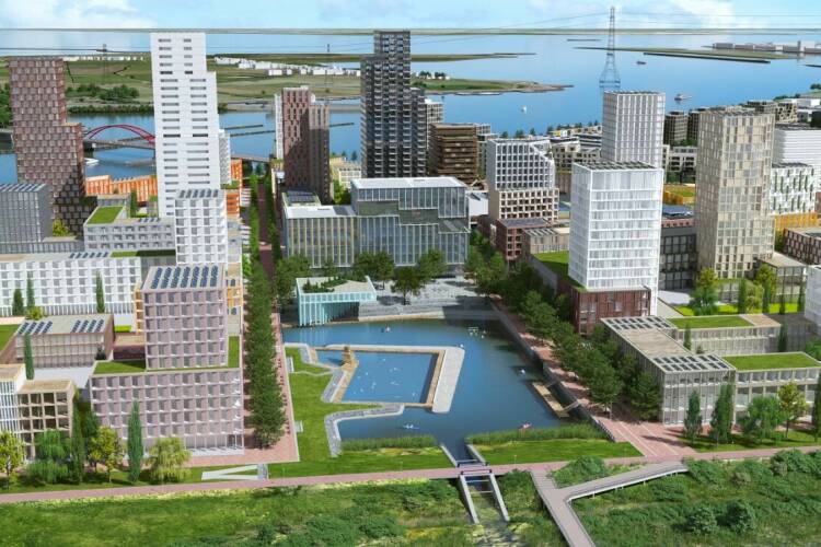
Impression of the Sluisbuurt on Zeeburgereiland, link towards IJburg
Podium and tower
The City of Amsterdam is introducing a new type of high-rise building in the Sluisbuurt district. The towers are built on a solid foundation measuring between 20 and 30 metres in height. Source of inspiration: podium-and-tower construction in Toronto and Vancouver. Milanovic believes this can result in a ‘block and tower’ typology in Amsterdam: “One of the advantages of building towers on top of a block is that they add homes, while the experience at street level is determined by an urban facade consisting of five to six levels. The substructure – which can accommodate homes, shops, and various facilities and amenities – adds a human dimension. We will be creating plinths that will be integrated into the public space – open and transparent. At the street level, we will create soft transitions from blocks to streets. Also, the streets of the Sluisbuurt district wil be given the same materials as the city centre and the Oostelijk Havengebied (Eastern Port Area): red paving bricks, and natural-stone details.”
Winner of the first tender – ‘Patchwork’, Barcode architecten, example of block typology with tower
Climate-proof
There’s another aspect Mirjana Milanovic took with her from Centrumeiland to the Sluisbuurt district: sustainability. The new residential island will be climate-proof and protected against flooding and heat-related stress. Rainwater is drained and transported to the IJ waterway through the canals, reducing the need for underground infrastructure and preventing the sewage system from becoming overwhelmed. The height of the Sluisbuurt district was increased using more than two metres of sand, which captures, filters and purifies rainwater. Each plot of land will consist of roughly 40% of green space, including 30% on the rooftop to moderate high temperatures in the summer.
The Sluisbuurt neighbourhood is based on the principles of De Bewegende Stad (‘The Moving City’). The area beckons us to explore it on our bikes, and by cycling, walking and exercising. Various facilities are available within walking distance, and the neighbourhood is a low-traffic area. In the Sluisbuurt, the City Council uses a parking availability standard of 0.3, half of that for the Sportheldenbuurt on Zeeburgereiland.
Diversity
The City of Amsterdam is looking for sustainable diversity in the Sluisbuurt neighbourhood, as elsewhere around the city, and this is reflected in the area’s homes. The district will be home to a total of 5,640 homes. Of the rental homes, 40% are public housing units, while 35% are mid-market and 25% are private-sector housing. These homes, the bulk of which are apartments, are intended for a mix of households. The Sluisbuurt will be home to families, young people, students and senior citizens.
In 2023, a pop-up incubator will open on the island, featuring artists’ studios and a community centre. The first residents, who will be moving in between late 2024 and early 2025, will occupy the 289 mid-market rental units in the first Sluisbuurt tower, which was designed by the Architekten Cie architectural firm. By that time, Hogeschool Inholland will also be located on the Waterbassin (Water Basin) (designed by cepezed architecten) and a section of the square will have been completed (on the square in front of the school). This will be followed soon after by an initial self-construction project featuring 20 homes, a primary school, and 800 student housing units.
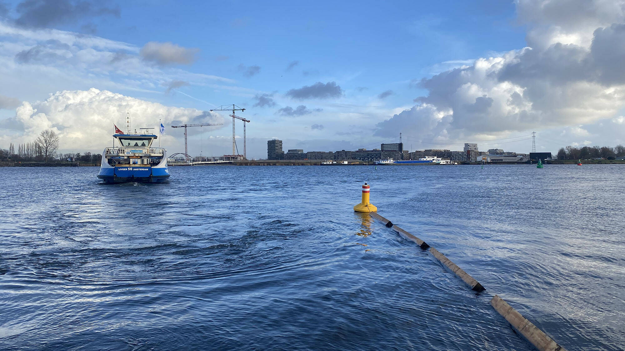
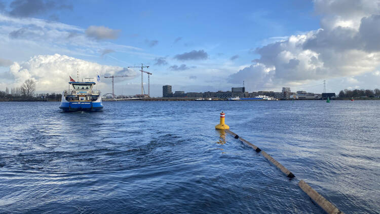
The first day of the ferry (photo: Mirjana Milanovic)
Accessibility
What about the distance to the city centre? How will the first and later residents overcome that distance? Milanovic: “Making any island accessible is always a challenge. There are still some issues near the Sluisbuurt district.” The IJtram is currently the only public transport link. The bike bridge to Sporenbrug, which was scheduled, has been cancelled. As an alternative, there is a ferry, from January 2023 on already, between the Sluisbuurt district and the Oostelijk Havengebied (Eastern Port Area). The City also intends to make the area more accessible by bike, by improving the bicycle route across the Amsterdamsebrug bridge. Mirjana Milanovic believes in a more permanent ferry system: “The Sluisbuurt district will then be part of the Oostelijk Waterfront area.”
Want to know more?
For further information – plus videos – on the various topics: Sluisbuurt op Zeeburgereiland (Sluisbuurt on Zeeburgereiland)


By: Hans Fuchs
Photo credit: Paul Tolenaar
Around a decade from now, the top of the Zeeburgereiland island will be home to a brand-new Amsterdam district: the Sluisbuurt. On the banks of the Binnen-IJ waterway, this residential island will boast green areas and high-quality public space. Right behind, the district starts its giddy ascent, with 17 residential towers creating a powerful urban skyline. So why this focus on the water? What’s with all these towers? And how do the designers integrate sustainability into the public space? Chief designer Mirjana Milanovic outlines the plan for the Sluisbuurt district.
The skyline of the Sluisbuurt district tells a story: ‘Look, the city doesn’t end there! There’s more! We’re seeing the start here of a whole new section of Amsterdam: the Zeeburgereiland and IJburg island group.’
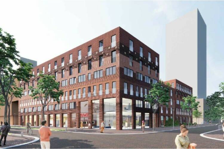
DUWO student housing, Mei architecten
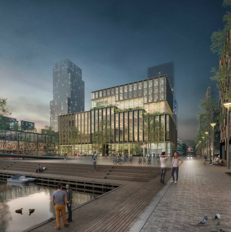
InHolland University of Applied Sciences, cepezed
Sluisbuurt 2030, Waterplein with InHolland building, cepezed and Justus tower, Architecten Cie
Urban planner Mirjana Milanovic: “Just look at it: the Sluisbuurt district and the water belong together.” “If you visit the bare, windy sand plain that currently makes up what will become Sluisbuurt district, you can instantly see what makes this spot so special: the water and the unobstructed and panoramic views.”
Milanovic incorporated both these assets into her Urban Development Plan. “The entire waterfront in Sluisbuurt will be used as public space, with the Sluispark section at the farthest point, near the Oranjesluizen sea locks. This will become a metropolitan public space – and not just for the neighbourhood residents. We are using the construction of the Sluisbuurt in order to put the Oranjesluizen locks back on the ‘mental map’, so to speak, of all Amsterdam residents, as part of the city.”
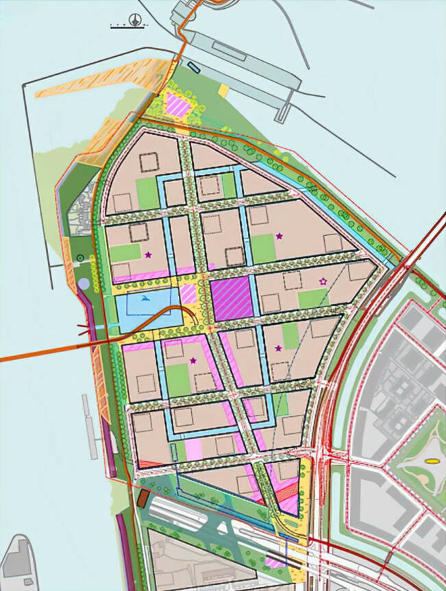
Sluisbuurt water connections, zoning map 2017
Water basin and canal structure
The Waterbassin (Water Basin) will form the heart of the Sluisbuurt district; it will be the central public space in the area. This is where the ferry from the Oostelijk Havengebied/Eastern Port Area will dock, and right there will be the Inholland University of Applied Sciences buildings. The City of Amsterdam is creating a new bicycle route towards IJburg, and there will be a neighbourhood square with shops, bars and restaurants, and community facilities and amenities. Water then takes over again as you progress farther into the area: a row of canals helps capture the rainwater in the middle of the Sluisbuurt neighbourhood.
Extending the city
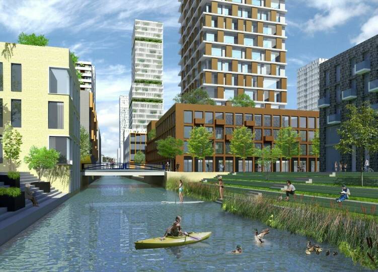
Impression of the canal with park and natural banks
Mirjana Milanovic
And then there are the panoramic views all around. The Sluisbuurt district is using this to its full potential, with medium-height buildings along the shoreline and 17 towers of between 40 and 125 metres in height. “Residents will be able to enjoy panoramic views: over the city, the village of Durgerdam, the Buiten-IJ waterway, Pampus, and further on, towards Almere.”
The towers will give Amsterdam a powerful new skyline on the Binnen-IJ waterway. This integrates seamlessly into the existing eastern view of Amsterdam, Milanovic says: “The waterfront is already very urbanised: just look at Buiksloterham, Java-eiland, and KNSM. The Sluisbuurt district has a special position, being located at the top of an island group and serving as a link between IJburg and the city. That is the image the Sluisbuurt skyline will project in the future: “Look, the city doesn’t end there! There’s more! This is the beginning of a whole new section of Amsterdam: the Zeeburgereiland area and IJburg.”
High density
Mirjana Milanovic has been working as an urban designer for the Amsterdam City Council for the past 25 years, and has been involved mainly in projects on the city’s eastside. She was the project manager and chief designer for Steigereiland and Centrumeiland and the driving force behind numerous self-construction projects.
Milanovic took one of the key challenges of Centrumeiland with her to the Sluisbuurt project: aiming for higher density and more new homes for the city. “It’s not just the location that determines the outlines of a design; I also look at time: what is important for the city, now and in the future? Densification by adding high-rise buildings with green parks is a good solution for the Sluisbuurt district, as this brings certain additional benefits. It’s about creating space all around the city; it generates better facilities and amenities and adds a sense of unity in the public space. It will also transform the Sluisbuurt district into its own core area in multicore Amsterdam, in line with the Amsterdam Urban Development Plan 2050.”
Impression of the Sluisbuurt on Zeeburgereiland, link towards IJburg
Podium and tower
The City of Amsterdam is introducing a new type of high-rise building in the Sluisbuurt district. The towers are built on a solid foundation measuring between 20 and 30 metres in height. Source of inspiration: podium-and-tower construction in Toronto and Vancouver. Milanovic believes this can result in a ‘block and tower’ typology in Amsterdam: “One of the advantages of building towers on top of a block is that they add homes, while the experience at street level is determined by an urban facade consisting of five to six levels. The substructure – which can accommodate homes, shops, and various facilities and amenities – adds a human dimension. We will be creating plinths that will be integrated into the public space – open and transparent. At the street level, we will create soft transitions from blocks to streets. Also, the streets of the Sluisbuurt district wil be given the same materials as the city centre and the Oostelijk Havengebied (Eastern Port Area): red paving bricks, and natural-stone details.”

Winner of the first tender – ‘Patchwork’, Barcode architecten, example of block typology with tower
Climate-proof
There’s another aspect Mirjana Milanovic took with her from Centrumeiland to the Sluisbuurt district: sustainability. The new residential island will be climate-proof and protected against flooding and heat-related stress. Rainwater is drained and transported to the IJ waterway through the canals, reducing the need for underground infrastructure and preventing the sewage system from becoming overwhelmed. The height of the Sluisbuurt district was increased using more than two metres of sand, which captures, filters and purifies rainwater. Each plot of land will consist of roughly 40% of green space, including 30% on the rooftop to moderate high temperatures in the summer.
The Sluisbuurt neighbourhood is based on the principles of De Bewegende Stad (‘The Moving City’). The area beckons us to explore it on our bikes, and by cycling, walking and exercising. Various facilities are available within walking distance, and the neighbourhood is a low-traffic area. In the Sluisbuurt, the City Council uses a parking availability standard of 0.3, half of that for the Sportheldenbuurt on Zeeburgereiland.
Diversity
The City of Amsterdam is looking for sustainable diversity in the Sluisbuurt neighbourhood, as elsewhere around the city, and this is reflected in the area’s homes. The district will be home to a total of 5,640 homes. Of the rental homes, 40% are public housing units, while 35% are mid-market and 25% are private-sector housing. These homes, the bulk of which are apartments, are intended for a mix of households. The Sluisbuurt will be home to families, young people, students and senior citizens.
In 2023, a pop-up incubator will open on the island, featuring artists’ studios and a community centre. The first residents, who will be moving in between late 2024 and early 2025, will occupy the 289 mid-market rental units in the first Sluisbuurt tower, which was designed by the Architekten Cie architectural firm. By that time, Hogeschool Inholland will also be located on the Waterbassin (Water Basin) (designed by cepezed architecten) and a section of the square will have been completed (on the square in front of the school). This will be followed soon after by an initial self-construction project featuring 20 homes, a primary school, and 800 student housing units.
The first day of the ferry (photo: Mirjana Milanovic)
Accessibility
What about the distance to the city centre? How will the first and later residents overcome that distance? Milanovic: “Making any island accessible is always a challenge. There are still some issues near the Sluisbuurt district.” The IJtram is currently the only public transport link. The bike bridge to Sporenbrug, which was scheduled, has been cancelled. As an alternative, there is a ferry, from January 2023 on already, between the Sluisbuurt district and the Oostelijk Havengebied (Eastern Port Area). The City also intends to make the area more accessible by bike, by improving the bicycle route across the Amsterdamsebrug bridge. Mirjana Milanovic believes in a more permanent ferry system: “The Sluisbuurt district will then be part of the Oostelijk Waterfront area.”
Want to know more?
For further information – plus videos – on the various topics: Sluisbuurt op Zeeburgereiland (Sluisbuurt on Zeeburgereiland)
