Old & News
Shipbuilding in the shadow of the Montelbaanstoren tower
By: Monuments and Archaeology
Images: Amsterdam City Archives, M&Z
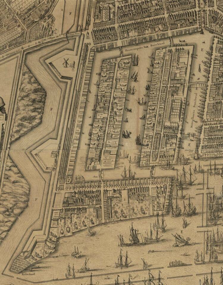
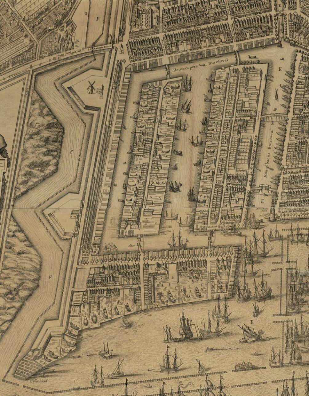
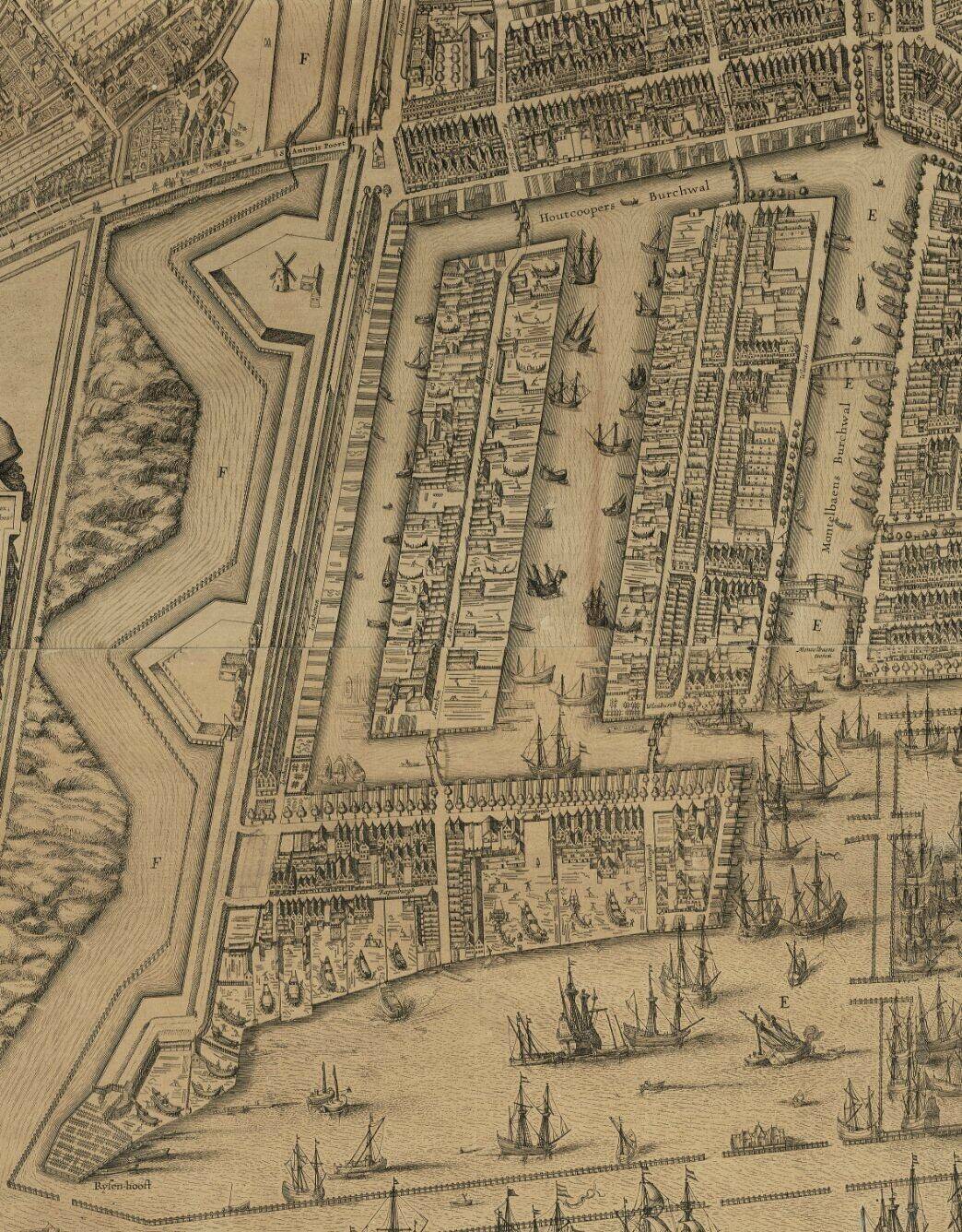
In May 1592, the Amsterdam City Council presented an ambitious new expansion plan. A new shipbuilding district was to be built in the outer dike areas between Sint Anthonisdijk (currently Jodenbreestraat) and the IJ waterway, with three islands to be used for the construction and maintenance of ships: Uilenburg, Marken and Rapenburg.
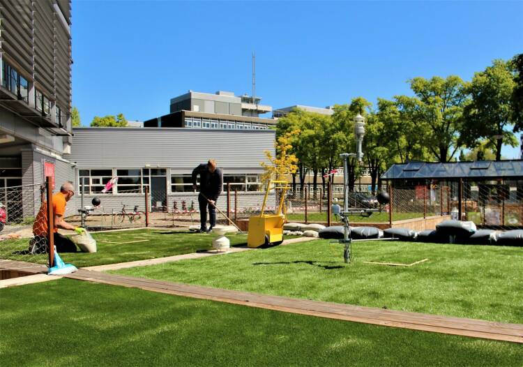
Innovation island at the heart of city living
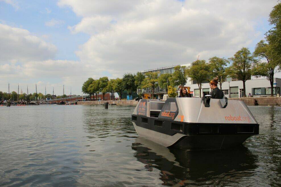
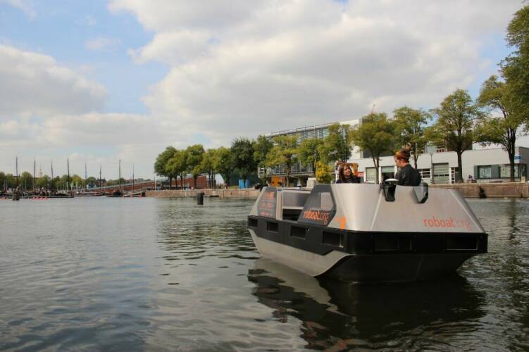
Everything from self-propelled boats to bio-based construction materials – anything is possible on the Marineterrein. Over the next few years, this testing area – formerly a closed military site – will gradually develop into an open, innovative city district. It’s destined to be a unique place to live, work, relax and experiment.
By: Jorien Rijntjes
Images: Bureau Marineterrein


In May 1592, the Amsterdam City Council presented an ambitious new expansion plan. A new shipbuilding district was to be built in the outer dike areas between Sint Anthonisdijk (currently Jodenbreestraat) and the IJ waterway, with three islands to be used for the construction and maintenance of ships: Uilenburg, Marken and Rapenburg.
By: Monuments and Archaeology
Images: Amsterdam City Archives, M&Z
From meadows to islands
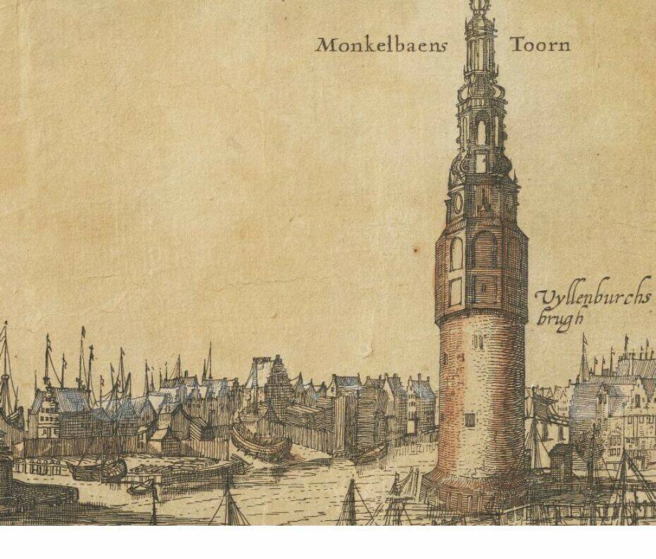
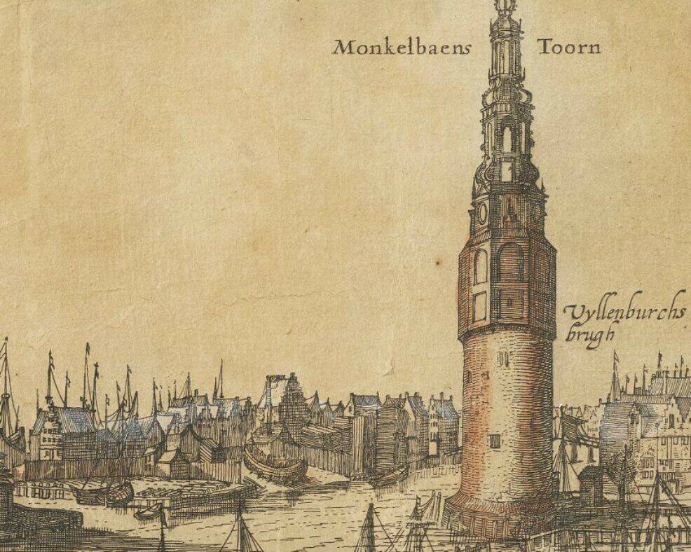
The islands were created by digging canals in the outer polder, and the new land was then used to raise the marshy soil of the islands. The northernmost island, Rapenburg, was propped up in the IJ waterway. The project was completed within a year: the first plots of land earmarked for shipbuilding were sold in December 1593 in the northeastern corner of Uilenburg, facing the Montelbaanstoren tower.
Uilenburg
The banks of Uilenburg – on Oudeschans and Uilenburgergracht – were home to large shipyards measuring nearly 1,000 square metres, with the homes of labourers and their families located in the centre. Within several years, most of Uilenburg was used for shipbuilding and ship maintenance. The ships built here were around 25-30 metres in length.
Slipways
We know what these slipways looked like thanks to an archaeological excavation at Oudeschans, which used to be home to Uilenburg’s original northern embankment. These were basic wooden structures measuring 30 metres in length and 5 metres in width, usually consisting of little more than a clay floor built on an embankment, which descended towards the canal. Subsidence was a common problem, which meant the slopes had to be repaired, replacing the wooden tread. This occurred on a total of three occasions at 75 Oudeschans between 1593 and 1620. The elevations often consisted of soil mixed with wood chips, which also tended to include objects used by the shipbuilders: nails, a chisel and, in one particular case, an actual wooden shoe.
After the collapse of the shipbuilding industry along Oudeschans in around 1620, a wharf was added to the embankment, and new homes were constructed on the site. The Uilenburgergracht lost its shipyards after 1660, when the eastern islands were completed and the shipbuilding company relocated there.


News
Innovation island at
the heart of city living
Everything from self-propelled boats to bio-based construction materials – anything is possible on the Marineterrein. Over the next few years, this testing area – formerly a closed military site – will gradually develop into an open, innovative city district. It’s destined to be a unique place to live, work, relax and experiment.
By: Jorien Rijntjes
Images: Bureau Marineterrein
Both within Amsterdam and further afield, we face complex challenges in areas such as housing, energy, green space and mobility. These challenges demand innovative ideas and the realisation and scaling up of existing methods and technologies. An essential part of this is experimentation and testing, preferably under realistic conditions.
As a defined area without a land-use/zoning plan, the Marineterrein offers ample space for this. Entrepreneurs, researchers and students are working together on ideas and projects aimed towards achieving a sustainable, liveable society, and they are able to test these immediately in practice. The Urban Innovation and R&D Team from the Digitalisation and Innovation Directorate is initiating various projects that will contribute to this. For example, a temporary building will be constructed in 2023 to test various innovations such as bio-based facade systems. Through the Shuttercam Project, the Responsible Sensing Lab is investigating how the use of cameras in public spaces can take into account values such as privacy, autonomy and transparency. Pilots will also be carried out using drones, for example.
Increasing the opportunities
The municipality is not only substantively involved in various projects, but is also investigating what is necessary to better facilitate opportunities both here and in the other seven Amsterdam innovation districts. Adapting the existing rules, requirements and work methods is also necessary for scaling up innovations.
An example is the testing of bio-based construction materials. Carrying out these tests in the built environment means that the effects of time, weather and location can be incorporated, as well as feedback gathered from end users. Because these materials are new, close consultation with the environmental department is required for obtaining the relevant permits and undertaking modified permit procedures if necessary.
New city district
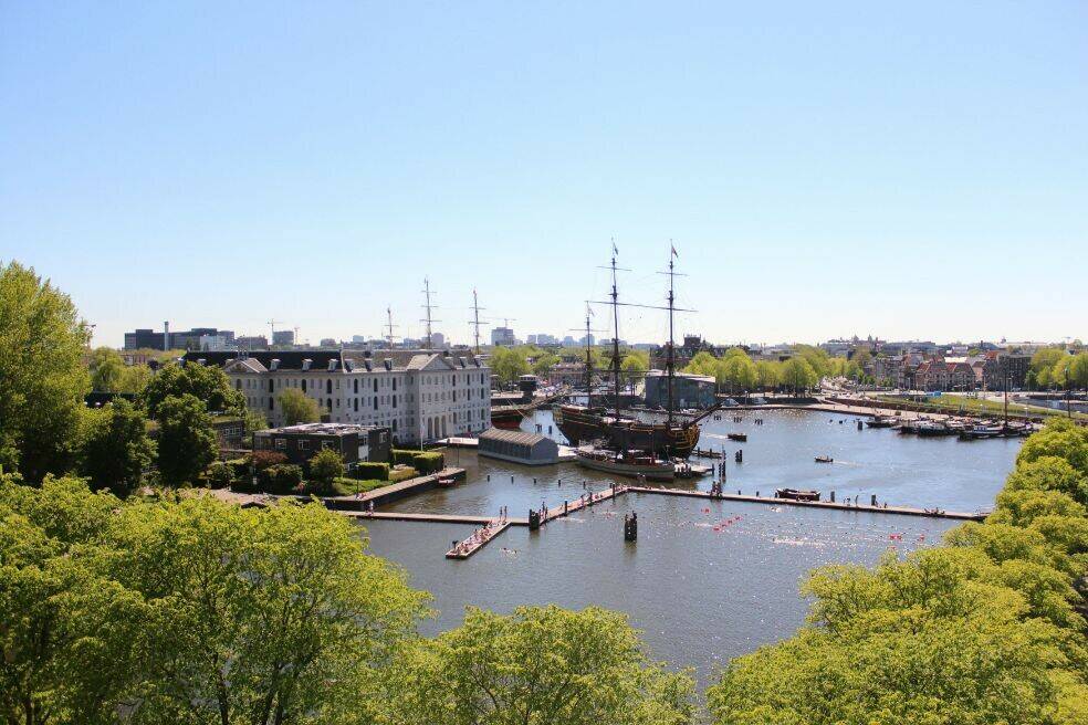
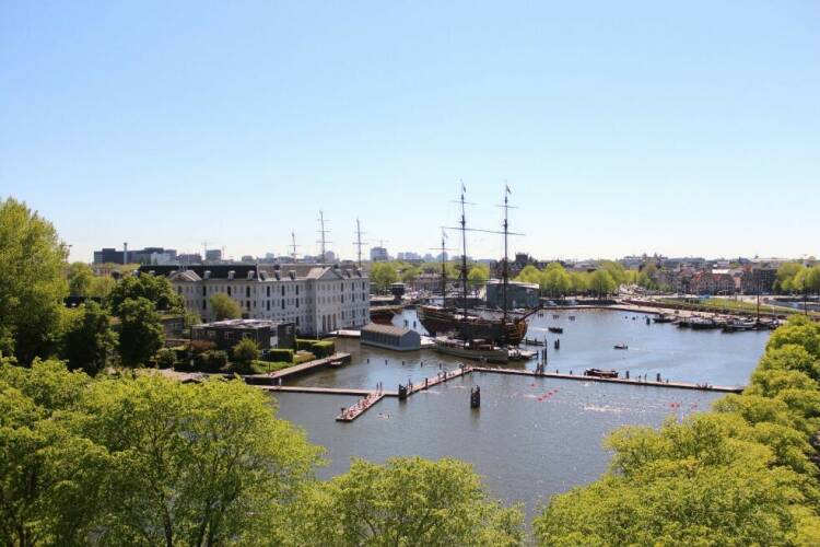
Amsterdam residents and other visitors are already well acquainted with the Marineterrein. They swim in the inner harbour, walk along the floating jetty or enjoy the green spaces. In the future, we hope to involve the residents on and around the island to an even greater extent in all of the innovations taking place there.
The physical redevelopment of the site will start in 2026 at the earliest. The Ministry of Defence will first build a new barracks to accommodate the currently rather scattered defence functions. There will also be a shared sports field for use by Defence staff and Amsterdam residents. Similarly to the current experiments, the redevelopment will proceed in a flexible, gradual way. Rather than a fixed, final result, there is an urban planning framework that gives an impression of what the future layout could look like. Both residents and users can actively participate in the plans.


Old & News
By: Monuments and Archaeology
Images: Amsterdam City Archives, M&Z
In May 1592, the Amsterdam City Council presented an ambitious new expansion plan. A new shipbuilding district was to be built in the outer dike areas between Sint Anthonisdijk (currently Jodenbreestraat) and the IJ waterway, with three islands to be used for the construction and maintenance of ships: Uilenburg, Marken and Rapenburg.
Shipbuilding in the shadow of the Montelbaanstoren tower

Innovation island at the heart of city living
Everything from self-propelled boats to bio-based construction materials – anything is possible on the Marineterrein. Over the next few years, this testing area – formerly a closed military site – will gradually develop into an open, innovative city district. It’s destined to be a unique place to live, work, relax and experiment.
By: Jorien Rijntjes
Images: Bureau Marineterrein

Shipbuilding in the shadow of the Montelbaanstoren tower
In May 1592, the Amsterdam City Council presented an ambitious new expansion plan. A new shipbuilding district was to be built in the outer dike areas between Sint Anthonisdijk (currently Jodenbreestraat) and the IJ waterway, with three islands to be used for the construction and maintenance of ships: Uilenburg, Marken and Rapenburg.
By: Monuments and Archaeology
Images: Amsterdam City Archives, M&Z
From meadows to islands
The islands were created by digging canals in the outer polder, and the new land was then used to raise the marshy soil of the islands. The northernmost island, Rapenburg, was propped up in the IJ waterway. The project was completed within a year: the first plots of land earmarked for shipbuilding were sold in December 1593 in the northeastern corner of Uilenburg, facing the Montelbaanstoren tower.
Uilenburg
The banks of Uilenburg – on Oudeschans and Uilenburgergracht – were home to large shipyards measuring nearly 1,000 square metres, with the homes of labourers and their families located in the centre. Within several years, most of Uilenburg was used for shipbuilding and ship maintenance. The ships built here were around 25-30 metres in length.
Slipways
We know what these slipways looked like thanks to an archaeological excavation at Oudeschans, which used to be home to Uilenburg’s original northern embankment. These were basic wooden structures measuring 30 metres in length and 5 metres in width, usually consisting of little more than a clay floor built on an embankment, which descended towards the canal. Subsidence was a common problem, which meant the slopes had to be repaired, replacing the wooden tread. This occurred on a total of three occasions at 75 Oudeschans between 1593 and 1620. The elevations often consisted of soil mixed with wood chips, which also tended to include objects used by the shipbuilders: nails, a chisel and, in one particular case, an actual wooden shoe.
After the collapse of the shipbuilding industry along Oudeschans in around 1620, a wharf was added to the embankment, and new homes were constructed on the site. The Uilenburgergracht lost its shipyards after 1660, when the eastern islands were completed and the shipbuilding company relocated there.


News
Innovation island at
the heart of city living
Everything from self-propelled boats to bio-based construction materials – anything is possible on the Marineterrein. Over the next few years, this testing area – formerly a closed military site – will gradually develop into an open, innovative city district. It’s destined to be a unique place to live, work, relax and experiment.
By: Jorien Rijntjes
Images: Bureau Marineterrein
Both within Amsterdam and further afield, we face complex challenges in areas such as housing, energy, green space and mobility. These challenges demand innovative ideas and the realisation and scaling up of existing methods and technologies. An essential part of this is experimentation and testing, preferably under realistic conditions.
As a defined area without a land-use/zoning plan, the Marineterrein offers ample space for this. Entrepreneurs, researchers and students are working together on ideas and projects aimed towards achieving a sustainable, liveable society, and they are able to test these immediately in practice. The Urban Innovation and R&D Team from the Digitalisation and Innovation Directorate is initiating various projects that will contribute to this. For example, a temporary building will be constructed in 2023 to test various innovations such as bio-based facade systems. Through the Shuttercam Project, the Responsible Sensing Lab is investigating how the use of cameras in public spaces can take into account values such as privacy, autonomy and transparency. Pilots will also be carried out using drones, for example.
Increasing the opportunities
The municipality is not only substantively involved in various projects, but is also investigating what is necessary to better facilitate opportunities both here and in the other seven Amsterdam innovation districts. Adapting the existing rules, requirements and work methods is also necessary for scaling up innovations.
An example is the testing of bio-based construction materials. Carrying out these tests in the built environment means that the effects of time, weather and location can be incorporated, as well as feedback gathered from end users. Because these materials are new, close consultation with the environmental department is required for obtaining the relevant permits and undertaking modified permit procedures if necessary.
New city district
Amsterdam residents and other visitors are already well acquainted with the Marineterrein. They swim in the inner harbour, walk along the floating jetty or enjoy the green spaces. In the future, we hope to involve the residents on and around the island to an even greater extent in all of the innovations taking place there.
The physical redevelopment of the site will start in 2026 at the earliest. The Ministry of Defence will first build a new barracks to accommodate the currently rather scattered defence functions. There will also be a shared sports field for use by Defence staff and Amsterdam residents. Similarly to the current experiments, the redevelopment will proceed in a flexible, gradual way. Rather than a fixed, final result, there is an urban planning framework that gives an impression of what the future layout could look like. Both residents and users can actively participate in the plans.

Contents
Nederlands